REQUEST TO DJI: Photogrammetric GPS and IMU data

Flylite

Member
Set your servo for 900, -900 and a short delay. But you'll need to use the photogrammetry function, not the scan to trigger the camera. just before you upload you should see the action in meters. Unfortunately, if you're also using a Zen with that Nex7 (like we are), you'll get usually two exposure for each action point. A pain. Almost as much as the fact the iOSD won't record time stamps for syncing the photo's gps data! Arrrrg! Still using a data logger.

Could you let us know if your using an F-channel for this? I have tired every which way but can't get this to work, F2 (r) I can control via F-channel keys if activated but can't via the photo tool or trigger (even with F-channel control unchecked for F2), cant make heads nor tails of this. Transparently these triggers are logged via IOSD but I cant see this either, confused!
 

leofuica

Member
For trigger camera via WK only F1 (F2 is for gimbal or other).
With GPservo action custom you can probe the settings until work, if dont trigger change settings, save settings and probe again...


Flylite

Member
Yes I understand that - I use the T,R as F1/F2 are used in octo config. I still need to map Tx to Wookong to control F1


Teresa G

Member
for real DJI looks like a stubborn company at the moment i'm using Naza m-lite with compass as a rookie but i will be using it for aerial photography soon so might be needing the data time of access log. now comes my HAD I KNOWN i would have gotten my self a APM instead of a Naza. well what else can we ask for as its an open system with free way points, Data access with no hustle. Cant wait for payday to ditch the DJI and go for APM :)


leofuica

Member
for real DJI looks like a stubborn company at the moment i'm using Naza m-lite with compass as a rookie but i will be using it for aerial photography soon so might be needing the data time of access log. now comes my HAD I KNOWN i would have gotten my self a APM instead of a Naza. well what else can we ask for as its an open system with free way points, Data access with no hustle. Cant wait for payday to ditch the DJI and go for APM :)

Teresa:

Hi, you can use yours system for that, but you need Datalogger (5 ó 10 Hrz) and a automatic trigger system for camera, or trigger via RC...and thats all....Bye
 

srbell

Member
APM is on the way out. Pixhawk is where it's at. Dual redundant sensors... Like GPS, Mag, airspeed and gyro. Even the Piski is supported. A lot of these new software features aren't supported by the 1.0 and 2.x APM boards anymore. And considering the price is pretty much the same, go PH.

Teresa:

Hi, you can use yours system for that, but you need Datalogger (5 ó 10 Hrz) and a automatic trigger system for camera, or trigger via RC...and thats all....Bye
 

Cratageus

New Member
Could someone please confirm that i am correct in finally thinking that S800 Evo, A2, Zen & Sony Nex 6, Futaba 14SG with twin R7008SB recivers (one for Zen) use in single pilot mode will never work with the Ground Station photogrammmetry program. Can fly route , but not take pictures as not using F1-4. ??
 

srbell

Member
About the A2, that's stated by DJI that there's no photogrammetry support. On the other hand, the photogrammetry functions are pretty weak compared to the likes of Mission Planner for the Pixhawd. The photogrammetry work flow for the WooKong is pretty crude, but it does work. Also, using the Zen is a disaster with the Wookong/photogrammetry as you won't be able to sync the photos to the GPS Exporter data. The zen with trigger more images than the recorded action so they won't sync and given there's no time stamp there's no solution. With the WooKong you'll want to use a servo or a gent led to trigger your camera and the weight of the zen is pointless for mapping. A cheap servo 2 axis gimbal will weight 1/3 the weight and do what you need. If you're using software like Pix4d Mapper, you really don't even need a gimbal. Your rig isn't a mapping rig, it's a filming unit : ) And that it does really well.


Could someone please confirm that i am correct in finally thinking that S800 Evo, A2, Zen & Sony Nex 6, Futaba 14SG with twin R7008SB recivers (one for Zen) use in single pilot mode will never work with the Ground Station photogrammmetry program. Can fly route , but not take pictures as not using F1-4. ??
 

leofuica

Member
Srbell:

I don´t work in DJI, but i have Wookong-m and the photogrametric tools works perfect for me, sync the photos y GPSexporter very well and take photos by distance or meters.
I don`t use DJI`s gimbal like Zenmuse (i use other brand) and my Nex was wired shutter by itself and take all the photos perfectly.
In Chile few people know how DJI´s works, is not hard to learn...i explain several times how its works but maybe....is really confuse..i know
 

srbell

Member
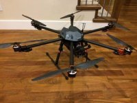
Yes, a Wookong that's not triggering a zen works fine with photogrammetry. I just wanted to clarify that so as not to confuse anyone. But compared to using Mission planner with Auducopter autopilots it's pretty clumsy. This is one of my mapping units that's still using a WooKong. View attachment 18548

Srbell:

I don´t work in DJI, but i have Wookong-m and the photogrametric tools works perfect for me, sync the photos y GPSexporter very well and take photos by distance or meters.
I don`t use DJI`s gimbal like Zenmuse (i use other brand) and my Nex was wired shutter by itself and take all the photos perfectly.
In Chile few people know how DJI´s works, is not hard to learn...i explain several times how its works but maybe....is really confuse..i know
 

Attachments

  • T950.jpg
    T950.jpg
    24.2 KB · Views: 289

saidquad

Member
I am planning to do a photogrammetric project using WKM + S800 + Z15 + Sony NEX7. Please help me on this. Do I still have to buy an IR shutter for NEX7 if I use Z15 and photogrammetry tool? I want to trigger the camera every 2 seconds.


saidquad

Member
Cratageus, you said on your earlier post that you are using A2. May be A2 is the issue for you. I am using WKM. First thing I should know is if the combination of wkm and Z15 and photogrammetry software is able to trigger nex7 every 2 seconds without using an IR shutter like TinySnapper or so.
 

srbell

Member
Triggering directly through the zen will cause serious problems with multiple exposures. Use a gent led or the tinysnapper. You'll get one photo per gps log entry. I have you're exact setup, but I have purpose built mapping rigs. The zen is overkill and severely limits you flight time.

Cratageus, you said on your earlier post that you are using A2. May be A2 is the issue for you. I am using WKM. First thing I should know is if the combination of wkm and Z15 and photogrammetry software is able to trigger nex7 every 2 seconds without using an IR shutter like TinySnapper or so.
 

saidquad

Member
Thank you srbell. I am also coming to this conclusion that Zen is overkill especially because the area of the project is 4 square kilometers! which means the bird has to travel about 34 kilometers to cover the area. So I have decided to use one of my quads which is capable of carrying NEX7 for about 25 mins. I will mount the NEX7 directly beneath the quad facing downward and use Tinysnapper. I just have two questions:
1- Don't know if 16mm,F28 (pancack) lens would do this job?
2- How harm it could have to use nex7 without gimbal for mapping (If take pictures in not a very windy condition and fly with horizontal speed of 5 m/s)?
 
Last edited by a moderator:

srbell

Member
The 16mm is fine for mapping, but quality all depends on the camera/lens calibration. If you're using Pix4D Mapper, then the calibration is currently in the database. If not, check with your software vendor. No gimbal depends somewhat on the software as well. There's lots of people mapping with wings with no stabilization successfully, that's the reason software has rapid processing to check that data is good before you leave the site. Nothing worse than getting back to the office and after half a day of crunching photos finding a big hole in you point cloud lol! If you're using the wkm in adaptive turn mode to overshoot the area as the turns are going to be at an angle. Of course the wkm won't even take an image if you're not flat and at the correct heading. 4sqkm is a big area, my mapping hex can barely do half that in a flight and I'm pushing about 45 min at 8m/s so you're going to have to do a number of flights. Don't forget to overlap about two legs between flight plans.

Thank you srbell. I am also coming to this conclusion that Zen is overkill especially because the area of the project is 4 square kilometers! which means the bird has to travel about 34 kilometers to cover the area. So I have decided to use one of my quads which is capable of carrying NEX7 for about 25 mins. I will mount the NEX7 directly beneath the quad facing downward and use Tinysnapper. I just have two questions:
1- Don't know if 16mm,F28 (pancack) lens would do this job?
2- How harm it could have to use nex7 without gimbal for mapping (If take pictures in not a very windy condition and fly with horizontal speed of 5 m/s)?
 

Top