PC Ground Station, Ace One WP and 900M Datalink to be discontinued

Hexacrafter

Manufacturer
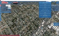
Put your location into the "search Locations" window at the top of the UGCS. It should take you to that location with the map on control station screen.
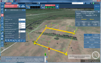
Select a point close to where you intend to take off from & program a take-off point. Then start mapping waypoints.....
Click "calculate route" & it will show the route..... & the click the same button to upload to the aircraft...
Take it outside & get everything powered up & confirm telemetry from the aircraft...
Click Auto Mode.....
It winds up & takes off.... & then flies the mission.
With DJI as it is currently configured, it will stop & hover at final waypoint. You have to then click return home for it to return to homepoint & land.


jetkrazee

Uplifting-photography.com
Yes very good connection, I'm using the free version right now,not sure if that makes a difference
I noticed for me personally I had to enter a zip code for my location and not just a city or town. Not sure if that will help or if you have tried that.
 

jetkrazee

Uplifting-photography.com
Here is what I got when I typed in Chatsworth. Notice the drop-down choices.
 

Attachments

  • CA.JPG
    CA.JPG
    201.1 KB · Views: 325


AirShooter

FlyCam UAV
Thanks for the help all!
I got it to connect to the 900mhz link and spin up the motors. I have yet to test it in real flight.
On another note as of today Dec 23rd the DJI PC ground station is still fully functional!


saidquad

Member
Hi Alex. In order to use DJI WKM and UGCS to do area scan, I have already configured the trigger action in vsm-dji.conf file:
1: In order to trigger camera every x meter, does the UGCS automatically command the camera trigger based on Photogrammetry parameters entered in area scan section, or I have to calculate the camera trigger distance based on area scan parameters manually and enter it in "Set camera by distance" section of the area scan?
2: For mapping huge areas, when I use DJI GCS I plan the entire route even though I can not fly the entire route at once and I have to land recharge and fly the rest of the route. So, on the first fly I start from waypoint NO. 0, on the second fly I start the same route but this time lets say from waypoint NO. 12 and so on... Is this also possible using UGCS?
3: It would be very helpful if UGCS shows the distance between each waypoint and the distance between route spacing in area scan as DJI GC.
 

Alex D

Member
In order to trigger camera every x meter, does the UGCS automatically command the camera trigger based on Photogrammetry parameters entered in area scan section, or I have to calculate the camera trigger distance based on area scan parameters manually and enter it in "Set camera by distance" section of the area scan?
Hi,
UgCS can control camera triggering. Common workflow:

1. Add AreaScan to your route, set GSD, overlapping and other parameters. Clear Additional waypoints flag if you want to control camera trigger by distance or time. Calculate mission. You will see picture like this:
View attachment 27126

2. In left bottom corner of UgCS screen you will see calculated values, in this sample:

01:17:13 Segment #2: Parameters of the area scan: size of footprint - 120.00 m x 88.49 m, the number of pictures - 36, distance between sequential shots - 35.40 m, time gap between sequential shots - 7.08 s. Please note that all values are estimates.

3. Select AreaScan and add Set camera by distance action:

View attachment 27127

(also you can use Set camera by time or Set camera mode actions if you want to use other methods of camera control).

4. Fill action parameters, copy distance from calculated values

View attachment 27128

5. recalculate route.

Please note that if you change AreaScan parameters you may need to change camera action parameters. In UgCS 2.9 we will implement automatic camera actions update, but in current version you should update them manually.
 

Attachments

  • upload_2015-12-26_1-22-6.png
    upload_2015-12-26_1-22-6.png
    917 KB · Views: 367
  • upload_2015-12-26_1-25-42.png
    upload_2015-12-26_1-25-42.png
    173.1 KB · Views: 340
  • upload_2015-12-26_1-28-25.png
    upload_2015-12-26_1-28-25.png
    178 KB · Views: 345

Alex D

Member
For mapping huge areas, when I use DJI GCS I plan the entire route even though I can not fly the entire route at once and I have to land recharge and fly the rest of the route. So, on the first fly I start from waypoint NO. 0, on the second fly I start the same route but this time lets say from waypoint NO. 12 and so on... Is this also possible using UGCS?
In current version no. Will be implemented in UgCS 2.9, 1Q 2016


saidquad

Member
Thank you Alex. I see the first shot delay in seconds option on "set camera by distance", but it would be also more practical for mapping to start the camera shot automatically from the first way point of the route and stop the shot after reaching the last point of the route to avoid unnecessary photos.


Alex D

Member
Hi, in current version (UgCS 2.7) you can change turn type for AreaScan only in configuration file vsm-dji.conf located in Bin subfolder of UgCS installation directory (by default it will be c:\Program Files (x86)\UgCS\Bin).

Open this file and find line

#vehicle.dji.turn_type_override = stop

replace it with

vehicle.dji.turn_type_override = adaptive_bank

In UgCS 2.8 it will be possible to change turn type for AreaScan from UgCS user interface.


Alex D

Member
RELEASE NOTES
IMPROVEMENTS AND CHANGES
  • Vehicle Home location is always visible on map as a green and yellow helipad
  • Implemented ADS-B Transponder (Sagetech ModeS) support for DJI
  • Implemented spline/adaptive bank turn option for Area Scan tool
  • Added Click & Go mode for all DJI vehicles
  • Created automatic trigger by distance and by time calculation for Area Scan
  • Added Micropilot support in U|g|CS - it is possible to use Micropilot simulation with U|g|CS
  • U|g|CS client window can be resized by click and drag and full screen button on window edge is functional
  • Updated telemetry window layout thus more information in a smaller window is available
  • Implemented full support for all previous ArduPilot firmware versions
  • Improved Area Scan algorithm for figures with sharp corners and added default camera trigger for all points of the Area Scan
  • Added U|g|CS client skins option - user can chose between different color schemes
  • Added Zenmuse XT, Panasonic GH3, Sony Alpha A7s, A7r and RX100 to available payloads list
  • Created ability to copy an existing vehicle profile (making a duplicate)
  • Added DJI S900 and S1000+ to available frames list
FIXES
  • Fixed DJI A2 pioled vehicles skipping first waypoint for Area Scan missions
  • Corrected elevation profile window not appearing in some specific cases
  • Added Vehicle type parameter to vehicle profile - Multicopter, Fixed Wing or Helicopter
  • Corrected DJI A2 and WK-M abnormal wait and yaw issues in some specific cases
  • Geotagging now can be executed even if no correct altitude data is available
  • Fixed color of sky when route is positioned in high AMSL areas
  • Restored correct route import and export algorithm
http://www.ugcs.com/en/page/version-2-8


Top