PC Ground Station, Ace One WP and 900M Datalink to be discontinued

Hexacrafter

Manufacturer
Alex,
I will send a direct email about how we need it to work for the projects we designed for the DJI GS.
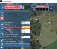
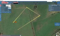
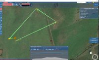
Basically with DJI GS, you can use the GS as a complete control center. So once the aircraft was linked up you can hit a button "auto take off". You set a altitude and it takes off and hovers at the elevation you set. Then it is click & go to a waypoint. You are prompted for an elevation for the waypoint and away she goes. It stops and hovers at that waypoint. You can use the keyboard buttons or joystick to yaw or control the pitch & roll of the aircraft. You can click and go to any additional waypoint even in mid flight to a current waypoint. One click to return home & she comes home and lands. If you have removed click & go from A2 & Wkm, then you have really made it useless for our needs.
 

Alex D

Member
Hi, click&go for A2/wkm will be available in UgCS 2.8
We will release this version later in December.
 

jetkrazee

Uplifting-photography.com
You could use UgCS for desktop mission planning with DJI vehicles. Our software does not rely on Google Earth API and therefore will still work. 900 MHz and 2.4 GHz data link systems work with our software. Feel free to check it out if interested: www.ugcs.com

You could use UgCS for desktop mission planning with DJI vehicles. Our software does not rely on Google Earth API and therefore will still work. 900 MHz and 2.4 GHz data link systems work with our software. Feel free to check it out if interested: www.ugcs.com
Hi,

I was wondering if you could explain what the function I have circled in red is and how to use it. I'm familiar with ground station software but a little confused on this.

Regards, jetkrazee (Forrest)View attachment 26981
 

Attachments

  • Capture.JPG
    Capture.JPG
    70.8 KB · Views: 301


Alex D

Member
Simply speaking GSD is a pixel size on the ground. If you enter 1 to this field every pixel of your photos will correspond to 1 cm (or inch) on the ground.

Based on GSD and camera parameters UgCS will calculate altitude and other parameters for your mission.
 

jetkrazee

Uplifting-photography.com
Simply speaking GSD is a pixel size on the ground. If you enter 1 to this field every pixel of your photos will correspond to 1 cm (or inch) on the ground.

Based on GSD and camera parameters UgCS will calculate altitude and other parameters for your mission.
Thank you Alex!
 

jetkrazee

Uplifting-photography.com
Just found out if you hold your right mouse key and scroll with mouse pad you can achieve a 3-d effect in UgCS. Awesome!
 

Hexacrafter

Manufacturer
Alex.
Sent you an email.
Purchased One & when I checked out it it said I would get email with activation code.
Never got code & cc has not yet been charged.
I also do not get a landing at programmed landing waypoint with my tests with free version. Please check your email & respond.
 

saidquad

Member
Alex.
Sent you an email.
Purchased One & when I checked out it it said I would get email with activation code.
Never got code & cc has not yet been charged.
I also do not get a landing at programmed landing waypoint with my tests with free version. Please check your email & respond.

so far I know the automated landing feature does not work with wkm and A2. Only features that were functional by DJI GCS will work with UGCS. Landing, camera rotations between waypoints,.... won't work. Also some settings (like RTL, Failsafe, Distance from ground on RTL, .....) in the DJI assistant software have the priority over UGCS and would be ignored by UGCS . Since DJI has hard coded things, It is not possible to make benefits of all capabilities of UGCS while using WKM and A2. For me it is a saver with better user interface compered to DJI and I really wish Alex could add the keyboard control and remove airport restrictions from UGCS ONE version. Keyboard Control is really a saver while RC signal is lost.
 

Hexacrafter

Manufacturer
Saidquad.
I believe you are confused as to the "power" of what DJI PC ground station was able to do that uGCS cannot. It is a lengthy list. Note that DJI Ground station DID have BOTH automatic take off & landing as programmed waypoints & click & go. Additionally, all of the joystick/ keyboard controls of all channels including Roll, Pitch, Yaw & F1 & F2. F1 & F2 could be used for a lot of things including camera controls, camera input switching, gimbal controls... etc. Set a new homepoint while in flight........ etc....
While I think that uGCS is a great option for those that have lost the DJI PC groundstation, they have a lot of work to do before it can be compared as an equal to the DJI PC ground station.
As mentioned above, I have purchased the ONE version and will be communicating with them about the deficiencies in the current ground station with hopes that they will add the same features that were offered by DJI PC Ground Station.
View attachment 26982
 

Attachments

  • ScreenHunter_01 Dec. 07 07.22.jpg
    ScreenHunter_01 Dec. 07 07.22.jpg
    61.7 KB · Views: 323

saidquad

Member
I guess I could not express myself clearly on my previous post (poor English). Anyways since I did use DJI GC only for mapping purpose for two years, the most important factor for me is to be able to use my DJI data link along with UGCS and plan a mapping route as easily as it was possible with DJI and the bird does the work by clicking the GO button. Shutting a photo at a specified distance is very important. And the most of all the keyboard control if losing RC signal. I have also purchased the ONE version of UGCS, but I have not tested it yet.
 

Hexacrafter

Manufacturer
I have been using the DJI PC ground station since it's initial release. Depending on our client needs, DJI GS was a need for many aircraft uses.
It was always lacking in it's ability to log GPS locations for "true" photometry".
I always felt like I had been ripped off by DJI as we paid for the waypoints when we bought the Datalink.... several thousand $$$... and then about two years later they gave 50 waypoints free to all the Datalink users.... like just stealing our money and giving out what we had paid for for free....
While I like DJI products for many reasons, I can say I am not a fan of their business ethics or practices.
I am VERY hopeful that the uGCS team will be responsive to the needs of a "real" ground station system and add support for the missing parameters.... we will see.
I have about 10 flights with uGCS... I was a bit caught of guard by the lack of the aircraft "landing" after running a waypoint mission... even though it had been programmed into the mission.....
I was lucky that I had enough GS experience to try normal click & go commands and RTH worked after it had finished the mission....
Just a heads up!!!!! uGCS does not like the issuance of a RTH command until the mission has run complete.....
In order to regain control of the aircraft, I had to unplug the DJI LK900 from the USB port & re-plug in during the hover at the final waypoint to recover control after issuing the RTH command during the waypoint mission.... not something I liked or recommend doing..... a bit scary!!!
 

Hexacrafter

Manufacturer
Just a follow-up for the Forum.
I have had several e-mails back & forth with uGCS.
They have been informed of the full capabilities of the DJI PC GS and are actively working on adding the additional features.
At this point, I wish to go on record as saying that uGCS has been very receptive, professional & responsive.
Great job uGCS!
 

Alex D

Member
Alex.
Sent you an email.
Purchased One & when I checked out it it said I would get email with activation code.
Never got code & cc has not yet been charged.

Hi, I didn't get any email from you. Or you contacted our support? Did they helped you?

It's better to send support requests to support@ugcs.com, all messages will be stored in our tracking system and routed to our support engineers. They all are very experienced UgCS users and drone operators and can solve practically any problem.
 

Alex D

Member
I am VERY hopeful that the uGCS team will be responsive to the needs of a "real" ground station system and add support for the missing parameters.... we will see.

We will make all our best. In situation when we compete with free GS from drone/autopilot manufacturers we should be better or die.

We just released UgCS 2.7 with some enhancements in AreaScan. Current limitations in DJI A2/WKM support described in document - http://www.ugcs.com/files/PDFs/Manuals/v2.7/manual-dji.pdf
 

AirShooter

FlyCam UAV
I downloaded the free GgCS. After a bit of trial & error I was able to get the connection via my 900 MHz DJI datalink. Now that I better understand the software, it connects and functions very well. I will be upgrading to the paid version. i am very happy that my DJI datalink is still a useful tool. Funny... These guys have done what the Billion Dollar DJI innovations who built and sold the datalink refused to do......
I just downloaded it as well however I cannot figure out how to make it show my current gps location on the map. I can hit auto and it fires up the motors to take off speed but It show me in another part of the world Help! Using the 900mhz link and the Naza V2
 
Last edited by a moderator:

jetkrazee

Uplifting-photography.com
FlyCam UAV, here is what the first screen will look like after placing a couple way points. I have circled the tab you need to click to process the route. The second screen shows what you click to upload it to the copter.
 

Attachments

  • First screen.JPG
    First screen.JPG
    113.9 KB · Views: 256
  • Second screen.JPG
    Second screen.JPG
    112.1 KB · Views: 246

AirShooter

FlyCam UAV
FlyCam UAV, here is what the first screen will look like after placing a couple way points. I have circled the tab you need to click to process the route. The second screen shows what you click to upload it to the copter.
The map is not showing my location so it makes it hard to plan a route


Top