Jason S
Member
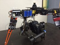
To anybody who is interested I recently added a laser altimeter to my old radian gimbal for my work. We do Construction/Development Photography or Balcony shots of high rise buildings so we need something super accurate. I finally made it happen it reads to the cm!!
I have attached a shutter cable directly to the laser and can set of the shutter at exactly required height. At the moment it will only take photos at one height perfect for 360 panoramas.
If anybody takes Construction/Development Photography knows this is very important. So if you do this kind of work let me know i want the company to add more "trigger points"
parts used :
fc: pixhawk fc
laser: sf11/c
http://www.lightware.co.za/shop/en/drone-altimeters/51-sf11c-120-m.html
osd: Alceosd 0v3
http://www.satxo.com/shop/index.php?id_product=8&controller=product
Its pretty well documented on how to set-up it does require some programming through the open source mission planner and cutting and soldering of wires.
documents are here:
http://ardupilot.org/copter/docs/common-lightware-sf10-lidar.html
thanks