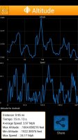
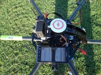
Did not see another post about this but was looking for a quick and easy way to record the altitude, speed and flight path of each flight. Found an app. named Altitude in the Google Play store. It records all 3 via the GPS in your phone. I simply Velcro'd and zip tied my phone to my hexacopter to make sure it did not disappear during flight. ;-) From the photos below you can see where I had the phone attached to the copter. As well, I have a screenshot of the altitude and speed graph over the duration of the flight. Just thought I would send out this info in case anyone wants a cheap method to track their flights. Enjoy!
View attachment 13021 View attachment 13022
View attachment 13021 View attachment 13022