You are using an out of date browser. It may not display this or other websites correctly.
You should upgrade or use an alternative browser.
You should upgrade or use an alternative browser.
Dji iOSD Application Good News if you own one..
- Thread starter VINHEX
- Start date
VINHEX
Member
Bug update:
Flight path not showing in Google Maps due to long flight times.. To many lines for file..
Solved:
Every odd line is added cutting down image lines..
View attachment 12472
Flight path not showing in Google Maps due to long flight times.. To many lines for file..
Solved:
Every odd line is added cutting down image lines..
View attachment 12472
Attachments
I'm trying to use this with the .dat files from my iOSD Mark II and my NAZA-M V2 but when I attempt the GPS Exporter (.dat to .txt) step, the files are 0 kb and of course do not work.
Is this a limitation of the NAZA? I notice that the GPS Converter you link to is in the WK section and unfortunately there isn't one for NAZA. I was hoping since it was the same iOSD .dat file, it wouldn't make a difference. Looks like it does.
Is this a limitation of the NAZA? I notice that the GPS Converter you link to is in the WK section and unfortunately there isn't one for NAZA. I was hoping since it was the same iOSD .dat file, it wouldn't make a difference. Looks like it does.
VINHEX
Member
Hi Globalcop, I've not done any testing on the Naza, but I would assume this to be the same as well.. My app needs the txt file to read as the DAT file is encrypted.. If the GPS Exported does not work then sorry buddy It's not going to work.. If you go to the link again where you downloaded you maybe able to upload your dat file there and I can take a look this end..
Vin
Vin
gtranquilla
RadioActive
I thought you were posting a link here.....
There is now an update on the app.. Requested ft & meters so added.. You will need to unistall last version and install the new using the links in the post here..
VINHEX
Member
Update
Here is the link again
Here is the link again
Please read: first...
This is an aplha test application.. And if you install it's at your own choice.. There maybe bugs but post them on here and ill try and support the best I can.. I can't support personal issues if something is not working its be added as a favour...
Instructions..
1: you need to download the GPS exporter from DJI site http://www.dji-innovations.com/download/wookong-m-waypoint-downloads/
2: copy the files install from https://www.dropbox.com/sh/lvu5et4y8jkof88/KbB_mDdh2C please copy do not drag and drop as this will remove the files from the server.
3: install google earth download from google if not already.
4: use the DJI GPS converter to convert your iOSD dat file into a txt format..
5: drag and drop the file into the black area above the map. Or use the menu file open and select the converted file.
6: click on. Any line in the data and this will point to that location and data select as you wish..
Flight:
Select start flight this will run through your flight showing you in the map below.. If you raise or lower the number on the zoom in the left menu it will zoom in and out.. The flight will continue until it reaches the end or your select stop flight..
Export..
Select export to google maps and save the file on your desktop.. Double click on file and it should open in google earth..
BUG.. I've had some issues but I think it's google earth that when finished google earth doesn't close down correctly only happens now and again.. But if does ie you double click on the file again and nothing happens you need to kill the service in manager on your pc..
Have fun load some examples up and again please it's install at own risk..
Vin
Hexacrafter HC650, DJI WKM, DJI DataLink 2.4Ghz, 3s 3300, 3s 5000, Aeroxcraft Landing Gear, Xoar 12x6 props, Spektrum DX8, AR8000 Receiver
TM1000, Fatshark Attitude SD, Sony Exview Had II CCD 650 Line Sony Effio-E
Fatshark Spironet Antenna's, DJI iOSD
I have a Mark II and the flight log reporter shows only the recorded home point for lat/long. And of course no live lat/long on the overlay. The .dat files are binary, and possibly secured. This is a high end unit, but they seem to want me to upgrade to the iPad Ground Station for $300 more to get function I expect to be present... and I think I have every right to expect latitude and longitude based upon their marketing descriptions: "The DJI iOSD MARK II can collect real-time video and flight data, which will help you to obtain the aircraft status information during flight. It can display power voltage, flight velocity, height, distance from the home point, horizontal attitude and GPS satellite number, etc." and "The DJI iOSD MARK II can record the flight log, which will help you to record the input and output information of *every channel*, GPS signal, power voltage, home distance and height, etc." They don't mention lat/long, and the local sales rep never mentioned that something so fundamental as lat/long is not included. This is *really* nefarious omission of information and as good as blackmail: "oh, you didn't ask about that.. for that you need to *more than double what you paid already*. DJI looks to its dealers to take care of customers. I am asking my local dealer to communicate to DJI that I want them to 1) add the lat/long into the live display and: 2a) provide me with a free Ground Station,or 2b) provide a .DAT file exporter as they do for the Wookong. Please tell your dealer that you want the same. The more people do this, the more likely this will get fixed. P.S. Dear DJI, if you don't fix this I'll exchange my iOSD for my $255 and I'll return to my Firebug 
djc:
Please upload a file to looking them...
I'm sorry, I don't know what you mean.
Jasonpandre
Eagle Eye Imaging
Wanted to say thanks for this software. Works a treat, although had to mess a bit with the GPS Exporter as my iosd has old firmware.
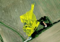
Ive vey seen somewhere (can't remember where) someone show the data in google earth with vertical height bar for altitude. Anyone know how? Mine shows just a line, with no reference to ground point.
Ive vey seen somewhere (can't remember where) someone show the data in google earth with vertical height bar for altitude. Anyone know how? Mine shows just a line, with no reference to ground point.
Can you make it output the time?Guys, I would just like to add a note... This is not a hac into any software.. This is using the data-reader GPS exported tool that DJI provide and I'm just using the data to create my own app.. for what I would like...
multi-prop-chop
Member
Love this software, but I wonder if anyone can help. Once I go through and convert everything to Google Earth, when I view the flight path, it never starts from 0 meters. i.e. it adds an amount of base altitude and when I try to alter this in the get info window it flattens out the flight path so I don't get a true visual interpretation of the altitude during the flight. Does that make sense?
Paul
Paul